Hi all,
My final day of activations on my May 2014 US trip was in Virginia. There are a series of Summits on the Air 10 point summits around Mt Pleasant, so that is where I was to go.
Mount Pleasant W4V/BR-005
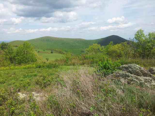
The first summit of the day was Mt Pleasant itself. I proceeded along Wiggins Spring Rd from the west. The road is a little rough, but can be driven in a 2wd in the dry with some care. I drove through to to the Mt Pleasant car park. From here, I proceeded by foot along the the old Jeep Trail. The alignment of the tracks these days has been changed from when the USGS maps I was using was surveyed. It’s pretty easy to follow, and after a little while a stream is crossed and the track begins to climb up to a point to the north, not far from the summit. Some people camped here overnight, and there was a sign pointing to a water source. I proceeded up to the summit area. I found that a number of people had been camping near the west summit. I had a look from the west, where there are nice views:
I setup a little bit back from the path, with the wire over the track (but about 10 feet up so it would have not affected anybody.
Things were a little slower than yesterday afternoon, but I still easily and quickly got the points here. After packing up and having a look at Mt Pleasant East summit, I headed back the way that I came to the car. I thought about giving Pompey Mountain a look on the way back, but thought it more important to get the four planned summits in today.
Cole Mountain W4V/BR-006
I had passed the car park for this summit on the way into Mt Pleasant. It’s only a few hundred yards back the road. The walking trail (the Appalachian Trail) from here zig-zags up on a mostly gentile gradient, but sometimes it’s a bit too gentle. There is a vehicular track also heading up, which they used to mow the lawn up at the summit. It proceeds up to the east of the walking trail where it crosses it on the climb. The vehicular track is faster getting up.
Once on top, there are great views because much of the ridgeline going across towards the highest point is cleared:
I operated just below the summit, behind a tree. There were lots of people out on the hill, so I went there for a little bit more peace for the activation.
Bald Knob W4V/BR-004
The Appalachian Trail continues down to CowCamp Gap and then up to Bald Knob. The gradient is quite pleasant with zig zaging reducing the workload. Bald Knob is not cleared, so no views from the summit here. I set up at the highest point, about 10 feet off the track. The number of hikers here was far lower than at Cole Mountain, but I did get someone asking what I was up to – the typical “what are you doing going fishing here?” I tell them that I am fishing for radio contacts.
At the end of the activation, I retraced my steps back down to CowCamp Gap, up to Cole Mountain and back to the car.
Rocky Mountain W4V/BR-001
The final summit of the trip was Rocky Mountain. I drove west back down Wiggins Spring Rd, turning right onto Coffeytown Rd. This rejoins Wiggins Spring Rd much closer to the summit. Wiggins Spring Rd is rougher here, and the humps to help the road drain must be taken with care to avoid bottoming out the car. A bit of practice with these back in Australia proved useful here in getting the 2wd car up to the top of the mountain, along with avoiding the rocks. You simply need to be able to drive using the whole road, left and right hand side.
This summit has a bit of comms gear on site:
It was a quieter activation here. I was running a little ahead of schedule, but I was keen to wrap things up quickly. The NiZn batteries performed like a charm, maybe just maybe I might even start leaving the LiPOs at home on Victorian activations?!
After wrapping up, I headed back home – literally! I carefully drove the car back down Wiggins Spring Rd, onto Coffeytown Rd, out to US60, onto the I81, up to Charles Town WV, onto the I70, I695, I95 up to Media PA, sleep for 5 hours, drive to Philadelphia airport, catch a plane to Dallas Fort Worth, another to LA, another to Melbourne, Australia (with broken sleep in economy class) and finally home in a daze.
All worth it, and going and activating places like Mt Pleasant and other SOTA adventures seems far more interesting than the usual tourist traps! For one, there were not any typical tourists that I saw on these travels.
So at the end of it all, the KX1 worked really well. I missed out on any VK stations, but it may have really been only my first activation back in W6 that had any real chance. Got a bit of EU action, and started to become familiar with various US SOTA chasers. Some have been in my log on VK summits. Hopefully I hear a few more from VK summits in future. Until the next activation….
Regards, Wayne VK3WAM


You must be logged in to post a comment.