Hi all,
I won’t be able to go out for an extended trip this Australia Day weekend, so I planned for a 2 day trip on Friday and Saturday the 11th and 12th of January to compensate.
False start for Mt Glenrowan
It was a interesting start to the trip on the Thursday evening. One of my cars gave a maintenance warning about half an hour into the drive, and so I turned around and headed home. I then used my other car for the trip. I headed up the Hume Fwy, but on arriving at the car park, I realised that I had left my bag of radio stuff at home. No end-fed antenna, no microphone, no activation. I headed back home.
Mt McLeod VK3/VE-034
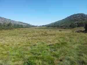
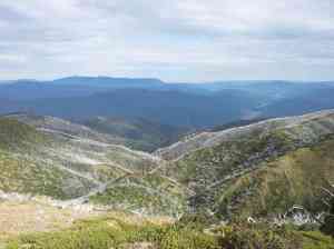
Perhaps that could have been the end of the trip, but one must be made of sterner stuff. It was up at 4am for the drive to Mt Buffalo to activate the four peaks on the plateau. Mt McLeod is one of the northern summits. It is reached using a rough 2wd track Reservoir Rd (marked Crystal Brook Rd on Google Maps) that leads off from the main Mt Buffalo Rd. There is a management vehicle track (bicycles allowed) that heads off to Mt McLeod at 800354. A bypass walking track is available for the first quarter of the way. The track skirts underneath Anderson Peak and continues NNE from there. There is a campsite at Dels Plain (with a toilet). No one was there when I got there. A nice view of alpine country from the campsite:
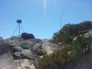
From the campsite, the track becomes rougher and after about 200m is a walking track only. It is still reasonably easy on foot up to the summit. Here is the antenna on the summit, a few metres from the trig point:
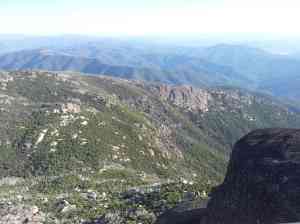
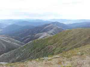
There are some nice views from this summit:
Ulrich Peak VK3/VE-038
From Mt McLeod, I headed back the way which I came along the walking track, which became a management vehicle track after the Mt McLeod campsite. This track is a little up and down but not too bad. It was a hot day, so I was going through the water at a good rate. I arrived at the Anderson Peak turnoff at 788368. This was signed, but the track is a quite indistinct, and I could not follow it. I followed the spur up the hill. Anderson Peak is to the ESE of Ulrich Peak, but it would seem that the saddle between them drops down about 30m, leaving Anderson Peak out of the activation zone. I made my way through heavy scrub and a little bit of rock scrambling across the saddle and up part of Ulrich Peak. I decided to pass going to the top itself, to save some time. I operated from a point about 15 metres vertical down from the summit at about 783367. There were a lot of trees and scrub around, so it was a bit of a challenge getting the end fed up. The feedpoint was close to a rock, which affected the match of the end fed, lifting SWR up to between 1.7 and 2. Still I got away with the points. There were no views from the operating location. I did find a better way down, and found a rock cairn of the “track” up Anderson Peak. I could still not follow the track, but it does seem that the summit can be accessed without getting into the really thick scrub.
The Hump VK3/VE-019
After further retracing my steps to the car, I headed back up Reservoir Rd and made my way up Mt Buffalo Rd to between The Hump and Le Souet Peak. It’s a climb of 160m up here. There is a remarkable rock formation called the Cathedral nearby, seen here with Ulrich Peak and Mt McLeod behind on the left and right respectively:
I operated from a location to the north east of the summit, about 10 metres down to keep out of the worst of the wind.
The Horn VK3/VE-014
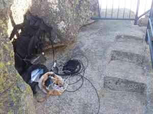
The Horn is effectively the summit of Mt Buffalo, situated near the southern end of the plateau. It is only a short walk up from the end of the road. The Horn is a rock formation, and a stairway and metal platform has been provided to enable non-rock climbers to access the top. This made it a bit interesting to set up my antenna system. The end-fed match did not like either end of the wire hanging off the metal railing. There was no electrical connection, but the railing in the near field of the antenna made the match terrible. I removed the feedpoint from near the railing and suspended it on some rope. This helped, and reduced the SWR from very high levels to around 2.5 to 3. Still not great, but at least I get an activation.
Here’s the station setup on the rockface:
The end-fed setup:
There were some good views from the top:
With that, it was back to the car and down to the Ovens Valley to prepare for another big day tomorrow.
Mt Feathertop VK3/VE-002
Mt Feathertop is the only true alpine style mountain in Victoria. It has many steep sides and spurs. I chose to access it via the Razorback which starts from near Mt Hotham. It is 11km one way to Mt Feathertop, so 22km in return. It took me about 2 and 3/4 hours to make the trip one way. The wind was picking up at the summit. One challenge was to work out a way of securing the squid pole with no large rocks or any trees around. Mt Feathertop is well above the tree line. I managed a configuration with the pole wedged on a small rock, but I did not raise the pole to the full height. Still it was enough to get a usable signal out there. There were a few other people on summit who wondered what I was up to. There was a much larger group at the intersection of the track with the side track going down to Federation Hut, about 30 people. They looked at that strange pole on the side of my pack and wondered what that was useful for.
Again great views from Feathertop. Much of the Victorian high country can be seen from here, as well as the Main Range in NSW. We look forward to being able to activate some of those VK2 summits in the future.
With that, it was time to head back the way I came to the carpark just underneath Mt Hotham.
Mt Loch VK3/VE-005
I headed out to Mt Loch first, to get the walking out of the way. I used an ARPS app on my phone to give people chasing an idea of when I might be on the air. The track out to Mt Loch is a bit hard on the feat, with the large aggregate used on the gravel road. I was happy to get out of the ski resort area, where the track became a little easier on the feet. It was a short activation near the summit, as the weather closed in a little and rain showers had started. Here’s a view of Mt Feathertop from Mt Loch.
Mt Hotham VK3/VE-006
Making my way back from Mt Loch, my car was parked only about 400 metres or so from the summit of Mt Hotham. I bypassed the car and headed up to the summit. I operated from just near the end of the highest chairlift on the summit. There is a fire watch tower nearby. There is also a large radio communication tower lower down. I operated from about 300 metres from here. There were some additional rain showers, so I did not operate for long. The temperature was also quite cool. I was happy to get back to the car and off the mountain.
The word about SOTA is certainly getting around. There are starting to become genuine pile-ups on SOTA activations. It’s nice to know that people out there are keen to get a contact from all of these nice places I go to.
Mt Glenrowan VK3/VE-230
Mt Glenrowan is a smaller mountain as part of the Warby Ranges. The Hume Freeway goes near it as it passes Glenrowan, about 230km from Melbourne. My route home was going past this mountain, and it was unfinished business from the start of this trip.
There are some tracks marked that approach the summit from the north east, but one of these goes over private land, and the other may not exist at all. The plan was to use Ridge Track from Taminick Gap at 293702. The car has to be parked at the gap, with the sealed road up to the nearby comms tower closed to private cars. It is a short climb up and then Ridge Rd, a gravel road, goes off to the right. This has a few ups and downs, but has a generally nice easy grade up to the summit. I was able to walk the 4.7km in about 50 minutes. The summit itself has some nice views, but I’m afraid it does not compete with what is seen from Feathertop or Mt Buffalo. I did get a nice sunset through while packing up.
It was time to head back to the car, with the last 30 minutes of the walk under a headlamp. Then back to Melbourne, arriving about 12:30am.
A very rewarding 2 days on the mountains.
Regards,
Wayne Merry VK3WAM






You must be logged in to post a comment.